No products
Prices are tax included


AERONAUTICAL CHARTS There are 42 products.
Subcategories
-

Avioportolano Charts
NEW FORMAT PLASTICIZED !!! The 2016 edition has been fully revised making it even better readability of geography and aeronautical information. All of Italy is given in six more 1 cards covering the Po Valley and cut a new minimal size for easy consultation on board. MAXIMUM LEGIBILITY!
-

Charts OACI-CAI
And 'the Charter Air Force Officer of the State for the National Air Space representation and shall carry the Italian commitment required dall'I.C.A.O. to member nations.
cartographic series intended primarily for civil users for VFR navigation.
The altitude is expressed in feet.
E'prodotta the scale of 1: 500,000 of 10 sheets. -

VFR FLY ITA Charts
NEWS: Italy VFR, plastic, scale 1,500,000 with 1,250,000-scale panels for more 'chaotic areas.
The aeronautical data is derived from the official AIP.
The table measures 148X80cm. -
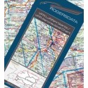
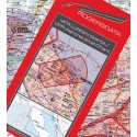
ROGERSDATA Charts
Charts VFR Aeronautical scale 1: 500,000 published by Rogersdata
-

JEPPESEN Charts IFR
Charts Jeppesen IFR E (LO) for low-level flights
They include all information, such as VOR, VORTAC, NDB, ILS. Printed on both sides of the -
Carte VFR Rogersdata...


 1/2")


